

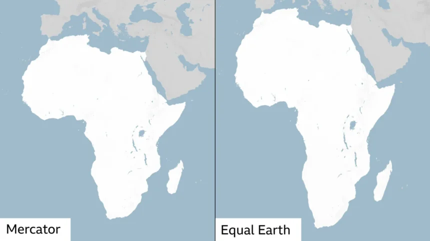
The United Nations General Assembly has passed a landmark resolution to phase out the traditional world map in favor of a projection that accurately represents the size of Africa.
The “Correct the Map” proposal, sponsored by Togo and supported by the 54 member states of the African Union, was approved with 164 votes in favor. France and the United Kingdom voted for the change, while the United States was the sole nation to vote against it. Six countries abstained.
While non-binding, the decision will change the maps used across international institutions, educational systems, and media organizations.
The traditional Mercator projection was created in 1569 by Flemish cartographer Gerardus Mercator to assist European ship navigators. Flattening a curved, three-dimensional globe onto a two-dimensional map requires trade-offs. The Mercator map maintains shape but distorts size, shrinking areas near the equator and enlarging landmasses closer to the poles.
Because of this distortion, the Mercator map displays Africa as roughly the same size as Greenland, even though Africa is actually 14 times larger. Critics contend that this centuries-old visual bias undercounts the true scale, economic potential, and development needs of equatorial countries.
To solve the distortion, a group of cartographers developed the Equal Earth projection in 2018 to display all continents at their proper proportions. The African Union formally adopted the Equal Earth model in February, stating that it “more accurately represents the sizes of all continents, particularly Africa”.
Togolese Foreign Minister Robert Dussey emphasized the broader meaning of the diplomatic push ahead of the Assembly vote.
”A map is never neutral,” Dussey told a UN briefing. “It shapes perceptions, influences how the place of peoples and continents in the world is understood”. Speaking later to reporters, he added, “A fair world begins with a fair map”.